|
|
In Eastern margins of deltaic East Pakistan and about 5 miles to West of Comilla town, an isolated, low ridge breaks the monotony of the dead plain. It extends for about 11 miles North-south from Mainamati to Lalmai. In its widest parts, the ridge is about 3 miles across and its highest peaks attain height of only 150 feet or so.
Like Barind and Madhupur tract, this ridge represent small mass of quasi-lateritic old alluvium with the distinctive red clay, which, where exposed, colors the hill tops brick-red.
Rainfall is abundant; there are small springs near the peaks; valleys and hill-sides are lush green with vegetation. These highlands were formerly thickly wooded, but land-hungry local farmers have now pushed back the forest to the highest points and to patches of Sal trees on the slopes.
The ridge still retains considerable scenic beauty and charm of its own; in early spring, when the jackfruit and mango trees are in bloom and air is filled with mild fragrance and the first melodies of the song birds, the place is turned into veritable dreamland. Here live a few scattered remnants of the aboriginal hill people, Tipras.
Interesting material found all over Mainamati area is fossil wood. Specimens studied by experts reveal their relationship with the fossil wood groups of Burma and South India. But Lalmai-Mainamati today is more well-known for its fascinating Buddhist remains.
Twin names have significant link with past. "Lalmai" or Southern part is identical with "Lalmai-vana" of Chandra epigraphs, while Northern part recalls the name of the legendary Chandra queen Mainamati, now immortalized in local folksongs and ballads. There is hardly any doubt now that this was where the political and cultural center of ancient East Pakistan must have been.
During the course of building a road through these hills in 1875, workers accidentally uncovered the ruins of what at that time was thought to be "small brick fort". This was actually Buddhist monastery.
Incidentally, it was in the same area, some 72 years later, that the first Mainamati inscription, copper-plate grant of Ranavankamalla Harikaladeva dated 1141 Saka (1220 AD), was discovered. The record describes the capital city of Pattikera as 'adorned with forts and monasteries'. This city was located in Mainamati; the name survives in the modern pargana of Pattikera which includes Mainamati area.
Mainamati ruins were rediscovered during Second World War. While setting up an advance camp, troops came across ancient remains at a number of points on the ridge. Department of Archaeology was informed, but unfortunately, before any action could be taken, sites were extensively damaged. Military contractors and local brick hunters removed an unknown quantity of ancient bricks, callously exposing the remains to be plundered or even totally destroyed. In hurried survey that followed 20 sites were recognized and declared protected.
In more regular survey undertaken since 1954, more than 50 sites of varying size and importance were discovered; they lie scattered on the flat tops and slopes of the hills. Three of them have since been excavated: Salban Vihara, Kutila Mura and Charpatra Mura.
Mainamati excavations are significant: They represent the first major investigation of its kind in East Pakistan.
In the size and magnitude of the exposed monuments, in the variety and richness of recovered objects, and in the significance of the information they have yielded, these excavations certainly rank among the foremost in Eastern in indo-Pakistan, and when considered together with the many unexcavated sites in neighborhood, they may even bear comparison with those of Nalanda and Taxila.
Salban Vihara, the main site, is situated about the middle of the ridge. The name is derived from Sal forest, which once covered the whole area. Here, excavation during the winters of 1955 to 1957 and deep diggings for a few more seasons have exposed large Buddhist establishment at Paharpur in North Bengal and a wealth of material objects roughly datable to a period from 7th to 12th centuries AD. Excavated remains consist of a monastery, a succession of central shrines and a number of subsidiary structures, both inside and outside the monastery, all brick-built.
Roughly square in plan and formally arranged around central shrine, monastery is grand edifice with four wings, each 550 feet long, containing a total of 115 cells of more or less uniform shape and size. Its single entrance in the middle of North side with 74 feet wide front facade and 174 feet long brick-paved approach path is imposing.
All the walls of the monastery are massive, but the back wall is the most massive, being 16 and half feet thick. This feature together with the forbidding character of the gateway and the dreary look of the outer wall must have given the monastery the appearance of citadel. The reason for evolving architecture of this type may be found in the increasing wealth of such establishments and the insecurity of the times.
Deep diggings revealed for repair and rebuilding phases in the monastery, the earliest corresponding to Period III of the site and datable to 8th century AD. It was the most prosperous and flourishing period, yielding exceptionally rich harvest of antiquities of considerable historical importance and artistic value.
During next two phases (Period IV & V), original door passages and niches of the cells were bricked-up and new floors and thresholds were built on top of earlier remains, thus leaving clear traces of the changes in the occupancy of the monument. At the end of Period V, assignable to Chandras (10-11th centuries AD), the structure began to collapse; it was not reconstructed except in North wing. Remains of the last phase (IV) are scantily preserved.
From the evidence provided by large ensemble of datable objects, including copper-plate inscriptions, coins, seals and sealing, it is now possible to say with absolute certainly that monastery was built (together with cruciform shrine) by Sri-Bhavadeva, fourth ruler of Early Deva dynasty, sometimes in the early 8th century AD.
Two interesting features observed inside cells, namely fire-place and brick-pedestals, do not seem to have been provided in the original plan; most of them appear from the second phase onwards. It seems that though there was community kitchen in the establishment, the resident monks preferred to cook their meals individually inside their cells, while pedestals served the purpose of private worship, though there was central shrine for the community.
Unlike the monastery, central structures at Salban Vihara represent not one but several shrines, built successively in different periods and on different plans. They provide interesting evidence of the gradual transformation of traditional Buddhist architecture and of its merging into that of Hindu temple.
Remains of the first two periods are as yet very inadequately known. These are roughly assignable to Khadga and Rata dynasties, who ruled Eastern Bengal during 7th century AD.
The cruciform shrine of Period III was apparently built with the monastery as single complex on the same stupendous scale. It is exceedingly interesting piece of architecture, imposing and yet graceful. Ringed by embellished plinth with pointing angles and recessed corners, the structure resembles in its ground plan Greek Cross, 170 feet long, with chapels built in projecting arms facing the cardinal points.
Basement walls of its Eastern and Western projections are embellished with two courses of beautifully sculptured terracotta plaques, illustrating in bas-relief the mythology and folklore of countryside. This shrine, bearing striking resemblance to that of Paharpur, represents fully developed and finished example of 7-8th century Buddhist architecture of East Pakistan, which probably supplied prototypes for the monuments at Kalasan (778 AD) in Central Java and Pagan (1090 AD) in Burma.
The next two periods witnessed interesting transformation in the plan of the shrine, and some reduction in size as well, the cruciform shape being replaced by an oblong one of smaller size. Now fully open, spacious and functional, it is far cry from the traditional solid stupa and is much nearer to Hindu temple, though still lacking the decorative elements of the latter.
The scantily preserved remains of the last phase (Period VI) have been removed.
Excavations at Salban Vihara have exposed a number of subsidiary buildings including community dining establishment, oblong, pillared and votive shrine and two chapels inside the monastery and an interesting shrine with massive cells, columned terrace and colonnades outside. The latter differs from both cruciform and oblong types and seems to represent individual style not hitherto observed.
Kutila Mura, the second excavated site, is situated in Northern part of the ridge. Two season's diggings here have revealed the layout of three principal stupas dominating the site and a number of subsidiary buildings and stupas built around them and enclosed by massive boundary wall.
In form and style Kutila Mura monuments differ basically from those of Salban Vihara. The former represents traditional and the latter evolved style. Three main stupas standing in a row probably represent the three jewels of Buddhism: Buddha, Dharma and Samgha.
Foundation of the middle stupa was laid in the form of Dharmachakra, its hub being represented by deep shaft, and the spokes were formed by 8 box-chambers, where innumerable terracotta and clay votive stupas and sealing were enshrined. Associated with these relics were found pieces of a class of fine Buddhist sculpture in soft gray shale not known from any other site. Foundation shafts of other stupas also contained similar relics of tiny votive stupas and sealing.
Kutila Mura monuments fall into three main periods, the earliest dating from Khadga times (7th century AD) or even earlier. The terminal date is suggested by gold coin of Abbasid Caliph al-Mutassim billah (1242-1258 AD) found in upper level of the site.
Five epigraphically records discovered in this area refer to certain "Ratna-Traya" establishment, which was certainly located somewhere on Mainamati ridge.
Charpatra, third excavated site, is situated near Northern end of Mainamati ridge. Here, is short season of rescue operation, remains of small shrine, 105 feet by 55 feet, were uncovered. It has two distinct parts, open pillared hall in the front and cellar at the back. The exterior of latter was given variegated effect by combination of symmetrical projections and offsets. In this monument, a few important objects were discovered: Brass pot and four copperplate grants, three issued by the last two Chandra kings (11th century) and the fourth by local Hindu ruler, Sri Viradharadeva, of 12-13th century AD.
Plates mention "Ladaha Maadhava (Visnu)" temple. On the basis of available evidence, this temple may now justifiably be identified with Charpatra Mura shrine, which appears to have been built by Chandra king Sri Ladahachandradeva (1000-1020 AD); two of the land-grant were issued by him in favor of that temple.
Mainamati excavations have yielded exceptionally rich collection of valuable antiquities now housed in the local museum. Most of them come from Salban Vhiara. The collection from the other two sites is small, but together they contribute significantly to knowledge of ancient East Pakistan covering a period of about 700 years, from 6th to 13th century AD.
Among the collected objects, copper-plate grants are obviously important as original source material for history and authentic record of past. No fewer than 11 such plates recovered from excavations; these were issued by Khadga, Early Deva, Chandra and Later Deva rulers (7-13th centuries AD).
Ancient coins are equally valuable source of information. In Mainamati more than 500 gold and silver coins, including three hoards of 227 specimens have been collected. Notable among them are two Gupta and dozen post-Gupta 'Imitation' gold coins, a rare silver coin of Sasanka, a fewKhadga and Early Deva gold coins, a large number of Arakanese and hundreds of Arakan-type local (Harikela & Akara dynasty) silver coins and one gold and a few silver coins of Abbasid Caliphs.
Short dedicatory or votive inscriptions found on a number of images and on thousands of terracotta and clay sealing are of lesser importance, but not the three-line inscription on a few sealing bearing the original name of Salban Vihara and of its royal builder. Shirter inscriptions on pottery and other objects are of paleographic interest only.
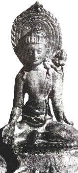
The sculptural fins in stone, bronze and terracotta represent the largest single group of antiquities other than pottery. This is the richest collection in East Pakistan, particularly in respect of bronze sculpture. Stone sculpture is rare, but it includes some fine specimen. Bronzes primary represent religious art and show perplexing variety of iconographic types, revealing the gradual transformation of the popular faith from Mahayana to Tantric and ultimately to polytheistic forms, in which Buddhism became inextricably mixed with Hindu and aboriginal elements.
The sculptured terracotta plaques are the most attractive and representative of local art. they are remarkable both for their variety and profusion and for their crude, but vigorous style and local character and development.
Among other finds, mention may be made of large collection of carved bricks, bronze relic caskets, gold silver ornaments, complete pots and a variety of objects of art and utility in metal, stone, bone and shell.
|
|